← Back
DeepCLiDAR supporting offshore wind development in South Africa
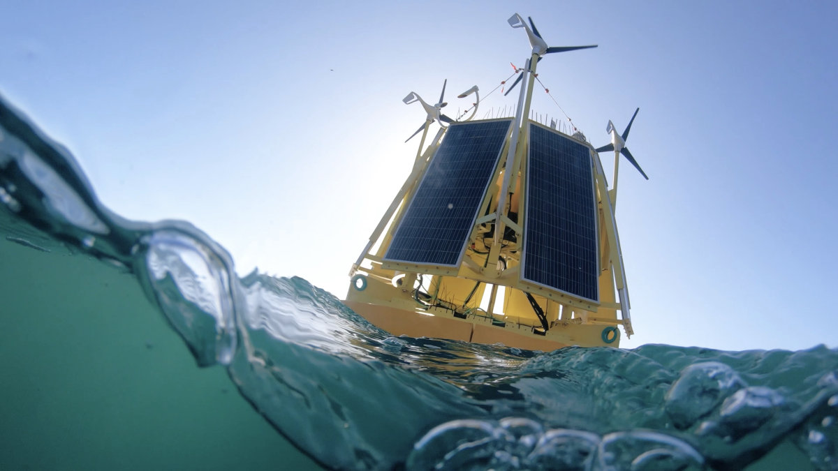
South Africa’s offshore wind potential raises a practical question: how can developers establish what a site can deliver, and under which operating conditions? Answering it requires reliable measurements of wind, waves and currents, collected where future infrastructure could be installed. DeepCLiDAR, CLS’s floating LiDAR system, brings these observations together in an autonomous platform. With production based in Cape Town and experience offshore South Africa, the solution connects local engineering capabilities with the Group’s expertise in wind resource assessment.
Understanding South Africa’s offshore environment
South Africa’s coastal waters offer opportunities for offshore wind, alongside demanding conditions for development. Water depth, strong currents and exposure to changing weather influence both the choice of technology and the preparation of marine operations. The World Bank’s work on the country’s offshore wind potential highlights the importance of floating technologies in accessing deeper-water resources. Understanding these environments requires site-specific observations to complement regional assessments and support engineering decisions.
For developers evaluating South African sites, measuring average wind speed is only part of the task. How does the wind change with height? How variable is it over time? Which waves and currents will installed infrastructure encounter? These questions affect energy yield estimates, turbine suitability and the plan installed infrastructure ning of offshore activities. A measurement campaign helps build the evidence needed to assess these factors together.
Mesuring wind up to 300 metres above the sea

Developed by CLS with Woods Hole Group and CLS Southern Africa, in partnership with the University of Maine, DeepCLiDAR combines a floating platform with a ZX 300M LiDAR sensor capable of measuring wind profiles up to 300 metres above sea level. Measurements at several heights help characterise the conditions across the vertical area in which offshore turbine blades operate.
The buoy also accommodates instruments for wave measurements and current profiling. Collecting atmospheric and oceanographic observations at the same location gives project teams a more complete picture of the site. This combined approach supports wind resource assessment and metocean characterisation, connecting the energy available above the sea with the conditions that infrastructure and vessels may face below and at the surface.
DeepCLiDAR is Carbon Trust certified under the floating LiDAR roadmap, following a validation campaign lasting more than seven months at the Woods Hole Oceanographic Institution’s offshore test site in the United States. Independent analysis by DNV assessed the campaign data against the roadmap’s performance criteria. This international validation provides a foundation for measurement campaigns in demanding environments, including South African waters.
From Capte Town production to offshore deployment

South Africa plays a direct role in the development of the solution. CLS established DeepCLiDAR production at its CLS Southern Africa premises in Cape Town, placing manufacturing capabilities within the country. This local base connects the platform’s industrial production with the Group’s international engineering and support network.
Preparing an offshore campaign begins with the measurement objectives and the conditions at the selected site. Water depth, expected waves and currents, required measurement heights and environmental monitoring needs inform the platform configuration. DeepCLiDAR’s modular construction facilitates transport and allows instrumentation to be adapted to the project, whether the campaign takes place in coastal, continental shelf or deeper waters.
Deployment planning must also address mooring arrangements, vessel access, power requirements and communications. Once installed, the buoy uses solar panels and wind turbines to support autonomous operation. Two-way Iridium Certus satellite and cellular communications enable data transmission and remote system management. These capabilities help sustain observations offshore while limiting the need for interventions at sea
Experience in South Africa waters
 DeepCLiDAR’s relevance to the local environment is supported by an actual South African measurement campaign. In results published in May 2025, CLS reported more than seven months of atmospheric and metocean observations from a location near a Marine Protected Area off the country’s southern coast.
The campaign recorded strong and rapidly changing winds, with speeds frequently exceeding 20–25 metres per second and approaching 30 metres per second during peak events. Overall system availability exceeded 99.9%, while post-processed data availability surpassed 96.6%. These results demonstrate the platform’s ability to maintain a high level of data continuity in the conditions encountered at that site. The campaign also supported testing of CLS’s turbulence intensity methodology, developed with Woods Hole Group, to improve understanding of wind variability relevant to turbine performance and structural fatigue.
Connecting offshore measurements with satellite intelligence

An offshore buoy provides detailed observations at a specific location. Assessing a wider development area also requires an understanding of how wind conditions vary across space and over longer periods. CLS combines DeepCLiDAR measurements with SARWind satellite-based wind assessment and high-resolution atmospheric modelling to address these complementary needs.
SARWind draws on Synthetic Aperture Radar observations of sea-surface winds, machine learning and atmospheric modelling. In-situ measurements provide a reference for evaluating and refining the resulting assessments. Together, these sources help developers investigate spatial variations, place campaign observations within a broader wind climate and develop a stronger basis for energy production estimates.
For South African projects, this approach offers a way to move from regional prospecting towards detailed site assessment. The combination of local measurements, satellite observations and modelling supports successive development decisions as knowledge of a proposed site improves.
Supporting environmental understanding
 Offshore wind assessment also requires attention to the surrounding marine environment. DeepCLiDAR’s modular design can accommodate additional instruments, including sensors for seawater temperature, conductivity, turbidity, dissolved oxygen and pH, as well as acoustic monitoring of birds and bats. The configuration depends on the objectives of each campaign.
These observations can contribute to environmental baseline studies alongside dedicated surveys and specialist assessments. In South Africa, where offshore development must account for marine ecosystems and other ocean users, collecting relevant environmental information early can help project teams better understand local conditions and identify questions requiring further investigation.
Building the evidence for future projects
For South Africa, progressing from offshore wind potential to well-founded projects depends on understanding the resource and the environment in which it would be developed. DeepCLiDAR contributes to that process through integrated measurements, adaptable instrumentation and experience in local waters.
By combining Cape Town manufacturing, offshore measurement capabilities and satellite-based assessment, CLS Southern Africa supports developers in building the evidence needed for their next decisions—from preparing a measurement campaign to assessing a prospective site.